Canada Part Deux, Eh!

Our hike around Lake O’Hara was one of the most spectacular we’ve ever done. Definitely makes the top 5.
We’ve said it before, but it bears repeating: if you haven’t spent time playing in Canada, you should definitely get your passport and visit our American neighbors to our north. Their National and Provincial Parks are as magnificent as ours, and as a bonus they have a better recycling programs. Seriously though - they have hiking parks and history parks and paddling parks and hot springs parks and all sorts of places that encourage you to get outside and play. Also, the exchange rate doesn’t suck right now, even if their gas prices are a bit higher than ours (depending on the state).

We got lucky and caught the larches turning colors as we headed south through Canada.
Last spring when we headed north to Alaska, we cruised through Canada in about 14 days. Coming back south, we lingered a bit and took 24 days. And it was worth it. We would have lingered longer if the weather has cooperated; alas, there was an approaching snow storm that (again) chased us out of the Waterton-Glacier National Parks. We love the fall shoulder season but have poorly timed our visit two years in a row now.

YOFOhome’s first ride on a boat - crossing the Yukon River.
Departing Alaska from the Chicken/Eagle area (yeah, we laugh too), our route took us across the Top of the World Highway. While the term “highway” is a stretch, the rest of the name fits. This gravel road takes you along a ridgeline with amazing fall foliage views in every direction. We didn’t see much wildlife on this stretch - at a roadside pullout we joked with several hunters that the caribou also knew it was hunting season. (More seriously, as a result of warmer temperatures, several caribou herds are not making their traditional migrations and are staying in higher/more northern terrain longer.) The Top of the World Highway is the northern-most border crossing; from there you drop you down and cross the Yukon River on their free ferry service, and then into Dawson City, Canada. It was a cool first for the YOFOhome (if a very tight squeeze) to cross a river on a ferry boat. And yes, jokesters, Dean was in charge of driving onto the boat since Dawn is has some lingering tight-space anxiety when it comes to towing the trailer.

Dawson City has a very cool vibe - it almost feels like you’ve travelled back in time. They are actively preserving and embracing the town’s history as a major travel hub for Americans seeking their fortune in the gold rushes. We were there Labour Day weekend (Canadian spelling), so several places were closed for the holiday. It’s a good thing we liked the town. About 50 miles past it we blew two trailer tires and had to return to get the tires repaired! We used Dawson City as a launch point to make a brief foray up the Dempster Highway, which goes all the way to the Arctic Circle (we didn’t go that far), in order to do a little bit of hiking in Tombstone Provincial Park. As with many places we visit, that short visit was enough to convince us to put it on the “must go back” list, which is getting pretty darn extensive at this point. It’s a good life when you keep visiting places that make you eager to return.

The photo is deceiving; that is a giant glacier miles in the distance along the aptly-named Iceline Highway

Who wouldn’t stop to enjoy a “little” beaver?
After our tire debacle, we beat feet toward paved roads and revisited the towns of Whitehorse and Watson Lake as we rejoined the Alaska Highway. We had “planned” our Alaska up and back routes so that we minimized overlap and got to see more beauty. There are a number of amazing provincial parks along the road and we enjoyed camping at Teslin Lake and Liard Hot Springs. Liard Hot Springs was beautiful; we’ve said before that hot springs aren’t our thing, but there’s a reason this place is a must stop along the Alaska Highway! We enjoyed a trip-best cinnamon bun at the Tetsa River Lodge - tiny place, tucked in, but not a place to drive by without grabbing a cinnamon bun. Wow! About this point, we realized that we wanted to put in a couple long mileage days (for us, about 300-ish per day) in order to have time to play in the six (yes, six) mountain Canadian national parks: Jasper, Yoho, Banff, Glacier (not the US one), Mt Revelstoke, and Kootenay.

Our favorite Canadian bakery and perhaps the best we’ve found in North America!
We arrived into Jasper planning to spend a couple days re-hiking a few trails that we’d been smoked out on (from wildfires) two years prior. Unfortunately for us, the weather gods turned fickle and it was drizzly and rainy and cloudy - so we stayed a couple extra days to try to luck into some patches of sun amidst the clouds. We were very lucky when we got up high in the Edith Cavell area and on our re-do of the Sulphur Skyline Trail as the clouds literally parted to allow us some beautiful views. We were less lucky in that the overflow campground area didn’t have rv tank fill water, so we were practicing extreme conservation as our planned two night stay stretched into five nights! We made it and only had to dump a few gallons in via funnel to take showers. Like we said, slow learners. As a side note, Bear Paw Bakery remains our top North American bakery, although we happily keep sampling any others we find to keep our list accurate.

Last time we did this hike in Jasper National Park, smoke obscured the views. No smoke and all smiles this time!

We battled rain most of our time in Canada, so we took full advantage of the periodic breaks. Here we’re hiking in the Edith Cavell area of Jasper.
From Jasper, we headed through Yoho to a campground between Mt Revelstoke and Glacier hoping that the weather would clear west to east. It was a good theory, but we basically visited those two parks in cloud cover and rain...43 degrees, raining, and a cloud ceiling below your hike elevation is not perfect hiking weather regardless of Dean’s annoyingly positive “let’s give it a shot, maybe it’ll clear up…” outlook. With steady rain in the forecast for the next nine days, we decided to add those two parks (especially Glacier) to our ‘we’ll be back’ list.
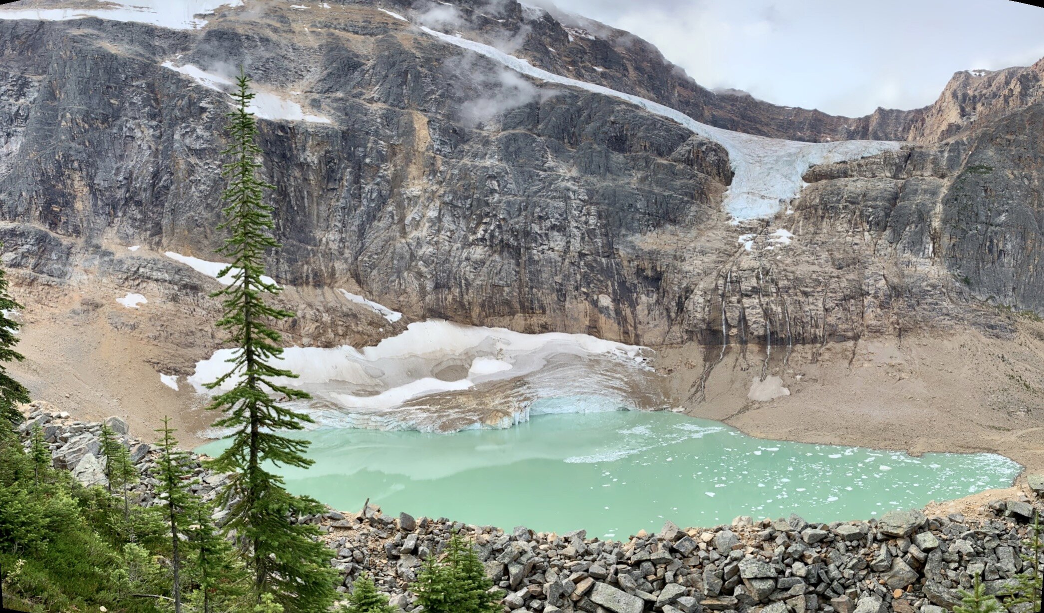
The turquoise green color comes from light bouncing off the glacial flour in suspension in the water.
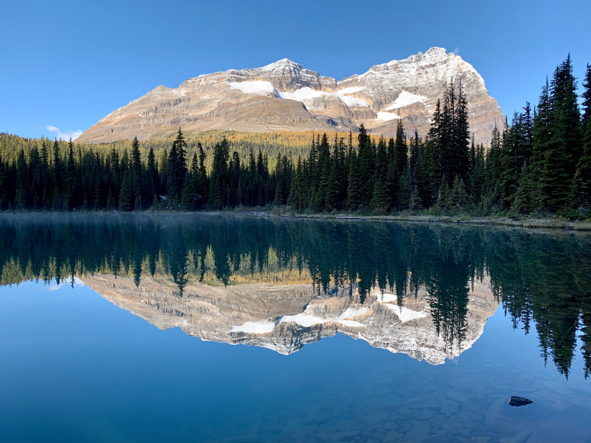
Early morning stillness on Lake O’Hara.

After hiking about 12 miles, a PBnJ-with-a-view tastes so good!
Yoho might be our favorite Canadian National Park, with Jasper a close second. Our first trip to Yoho had us finding the Iceline Trail - still in our top 5 hikes of North America list. Our second trip, well, we battled rain and clouds (and snow, yay!) and again extended our trip an extra few nights. We’re glad we did since we “discovered” the amazing Lake O’Hara region. One person described it as Lake Louise but without the crowds, but we think it might be prettier. It’s a good thing it turned out to be gorgeous since we hiked 7 miles just to get to the trailhead of our 8 mile Alpine Loop Trail because bus tickets sell out months in advance. It was worth every step. We will be returning to Yoho NP and can’t wait to keep exploring. We also went part way up the Niles Meadows Hike but decided we 1) wanted better weather and 2) needed to save a little something in the tank for the next day’s Lake O’Hara 15 or possibly 22 mile day (luckily we caught the bus back so only had a 15-mile day).

Views like this are around every bend of the Iceline Highway between Jasper and Banff.

Dawn owned a similar 66 Mustang when she was a young lass. We wish it was still in the corral!

Great food, beer and people. Go if you’re ever close to Invermere, Canada. Order the fried chicken.
We drove past the Lake Louise Area en route to Kootenay - it’s a beautiful place and we’ll end up revisiting it at some point, but we were anxious to get to Waterton and Glacier (the US park) and it looked like some forecasted rainy weather might turn snowy. We didn’t hike in Kootenay (more unfinished business), but we found a very cool nearby town (Invermere), an amazing restaurant (Ullr Bar), a very good bakery, a crazy cool car show, and did a fun hike in Bugaboo Provincial Park to their lower Falls. If you ever find yourself in the Radium Hot Springs-Invermere areas (and you should), do yourself a favor and go to the Ullr Bar. Amazing food (fried chicken and brisket, seriously), great beer, specialty cocktails, and some owners who are very sociable and gracious (with sort of a Canadian hipster Viking vibe. That’s a thing; trust us.). We’d drive out of our way just to go back there to eat. Kootenay/Invermere and Revelstoke seem to have a strong winter sports game going, in case sliding down hills on slats tied to your feet is your thing.

Dawn is sporting her Canadian jersey as we bike along Lake Waterton.
We crossed back over to the east side of the Rockies via Crowsnest Pass, which is a place that looks like it should be explored. Alas, we didn’t stop, because we wanted to get to Waterton and play. Also, we were beating feet because we had heard that six of Waterton’s eight camping loops were under construction and we needed a place to sleep! We did get a spot, and got to do a couple things that we didn’t get to last year. We rode our bikes out Red Rock Canyon road and saw a couple of bears grazing in preparation for the winter. We took the boat ride over to the Crypt Lake hike, which is on lots of publications “must do” lists. We honestly would’ve spent more time there playing, but large areas of the park remain closed due to the fire that went through two years ago and, well, the forecast showed an early season snowstorm bearing down on the Rockies. So, across the border to Glacier (US version) we went.

Canadian traffic jam.
As a side note, our two “best” experiences crossing back to the US have both been at Chief Mountain Border Crossing. The US agents there are professional, courteous, and ask relevant questions as opposed to the hazefest we’ve received at other crossings. We know that the agents have a job to do, so this isn’t a rant on those folks (we have other issues with their policies), but asking US citizens where they’re going or how long they plan to be in the US is BS in our book. Anyway, this crossing site also has a reasonably wide, height unrestricted lane which is nice and much appreciated! It’s not out of the way if you’re traveling between Glacier and Waterton, but we’d likely go out of our way to use this crossing spot.